MapStore 2026.02.00 发布:增强数据集成与目录体验
MapStore 2026.02 系列版本正式发布,作为旗舰开源 WebGIS 产品,本次更新在数据源集成、目录可用性、投影管理和小组件灵活性等方面带来了一系列增强。新版本标志着 MapStore 在向综合性平台演进的道路上又迈出了重要一步,不仅专注于地理空间可视化,更致力于无缝集成异构数据源和现代 Web 分析工作流。
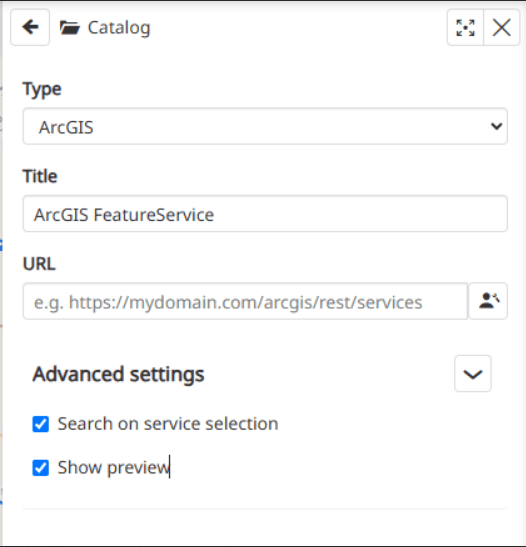
在数据源集成方面,v2026.02.00 显著扩展了 MapStore 原生支持的数据源范围。新增的 ArcGIS FeatureService 支持允许用户直接在 MapStore 中可视化通过 ArcGIS 查询端点暴露的矢量数据。该实现同时面向 OpenLayers 和 CesiumJS,采用基于瓦片的加载策略,按网格单元增量获取要素,而非一次性下载整个数据集,从而在处理大型 FeatureServer 数据集时实现性能与用户体验的良好平衡。此功能得益于热那亚市政府的贡献。
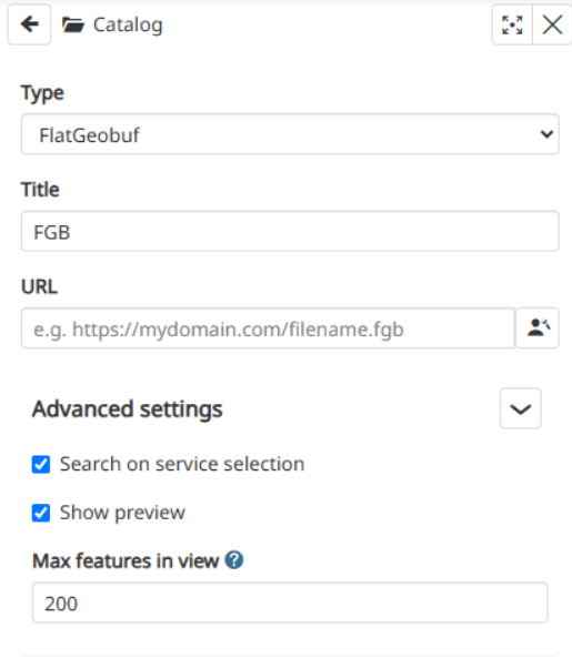
同时,新版本引入了对 FlatGeobuf 格式的支持,作为一种只读远程图层类型,在目录、图层树、地图识别和样式(包括要素样式的动态更新)方面表现一致。FlatGeobuf 数据集现在可在 2D 和 3D 环境中可视化,这得益于在 OpenLayers 和 CesiumJS 地图组件中的集成。此外,一系列增强功能引入了可配置的 maxFeaturesInView 选项,用于限制当前视图中渲染的要素数量,避免地图范围覆盖整个大型数据集时出现性能问题。该设置可在图层树设置和目录高级设置中使用,并统一适用于 OpenLayers 和 CesiumJS。图层树中还为 FlatGeobuf 图层启用了“缩放至”操作,与其他图层类型的用户体验保持一致。这些改进得益于 TotalEnergies 的贡献。
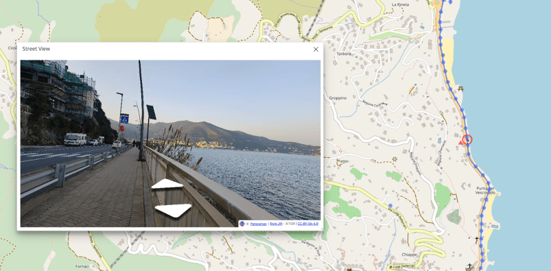
街景插件也迎来了新进展:Panoramax 作为新的提供者加入,使用户能够探索由 Panoramax API 提供的街景影像。该集成包括专用配置选项、本地化支持和适当的归属处理,进一步丰富了 MapStore 中可用的上下文影像来源。此功能由 Open Groupe 贡献。
图层目录经历了本发布周期中最重大的重构之一,从用户体验和架构两个层面进行了革新。原有的 MetadataExplorer 插件被完全重做并更名为 Catalog,采用了全新的布局和主题,复用了平台中已有的资源目录组件。除了视觉和结构上的重构,新目录现在还原生支持 GeoNode API 作为目录服务,与其他支持的源类型(如 WMS、WFS、WMTS、TMS 等)并列。这为最终淘汰 GeoNode 内部历史维护的独立自定义目录奠定了基础,推动两个项目向更统一的体验迈进。目录重构得益于 TotalEnergies 的贡献。 在上一系列 CRS 改进的基础上,2026.02.00 版本引入了动态投影定义功能,将 MapStore 的坐标参考系统管理直接连接到一个 GeoServer 端点,该端点暴露了数千个标准化 CRS 定义。管理员和具有相应编辑权限的用户现在可以直接在 CRS 选择器中按需搜索、添加和删除投影,而无需重新部署应用或手动编辑配置文件。现有的静态配置投影继续照常工作,确保与当前部署完全向后兼容。对于处理大量或不断变化的坐标系统的组织来说,这一改进尤其有价值,因为灵活性和快速迭代至关重要。此功能得益于 TotalEnergies 的贡献。 小组件体验也在持续演进,重点关注灵活性、布局一致性和可定制性。得益于那不勒斯大学的贡献,新增的自定义小组件类型允许在小组件容器内渲染其他插件暴露的任何组件。与现有的预定义小组件不同,自定义小组件可以像其他小组件一样展开和最小化,为完全定制的仪表板内容打开了大门,并支持高级用例。 如需了解完整的更新列表和技术细节,请访问 GitHub 上的 v2026.02.00 发布页面,或直接在 MapStore 演示中体验新功能。
编译自 Planet OSGeo,原文链接
原文摘要
MapStore 2026.02.00 Release
Here is a closer look at the highlights of the new series of , our flagship is possible to consult the of new features, enhancements and fixes we have provided in version 2026.02.00. You can try it right away on the .2026.02MapStoreOpen Source WebGIS product. On GitHub itMapStore demofull list If you are interested in learning more about how we can help you develop a WebGIS using MapStore or help you achieve your needs with , and through our , and please !, MapStoreGeoServerGeoNodeGeoNetworkEnterprise Support ServicesProfessional Training ServicesSubscription Servicescontact us The team,GeoSolutions Municipality of Genoa, TotalEnergies, Open Groupe, University of Naples, KfW and Deutsche Bahnv2026.02.00ArcGIS FeatureServiceMunicipality of GenoaTotalEnergies is now available as a new provider for the Street View pluginPanoramaxOpen Groupev2026.02.00completely reworked and renamed to CatalogGeoNode API as a catalog serviceTotalEnergiesTotalEnergiesCustom Widget University of Naplesv2026.02.00 release pagesupport for the FlatGeobuf formatPanoramax APIDynamic Projection DefinitionsTimeline plugin has also received a layout review Expanded Data Source Support A Redesigned Layer Catalog Advanced CRS and Projection Management Widgets and Timeline Greater Flexibility in Data Access and Configuration System and Infrastructure Updates maxFeaturesInViewMetadataExplorer Improved spacing and layout in the catalog's dialog mode. Removal of duplicated legacy catalog components, now centralized in the core. A fix preventing the catalog page from reloading and resetting when switching layout. Alignment of template and default catalog configuration, including the removal of the default COG service entry. A fix for GeoNode services showing the category identifier instead of its human-readable label on catalog cards. : by default, MapStore crops WMS layers to the current map projection extent. A new option now allows users to let OpenLayers request tiles beyond that extent, conf